Found some Flickr Pic's with personal views. Enjoy
I know I said no more pic, but I found these with a human touch, not a news photographer.
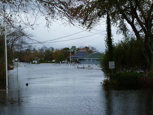
mdpNY's
Uploaded on Oct 30, 2012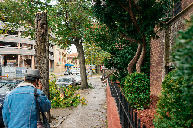
Sandy_JH_mdpNY-1
Jackson Heights, Queens the morning after Hurricane Sandy passed over NYC.

Midtown Reflection. Butts and sky.
Mike Druckenbrod
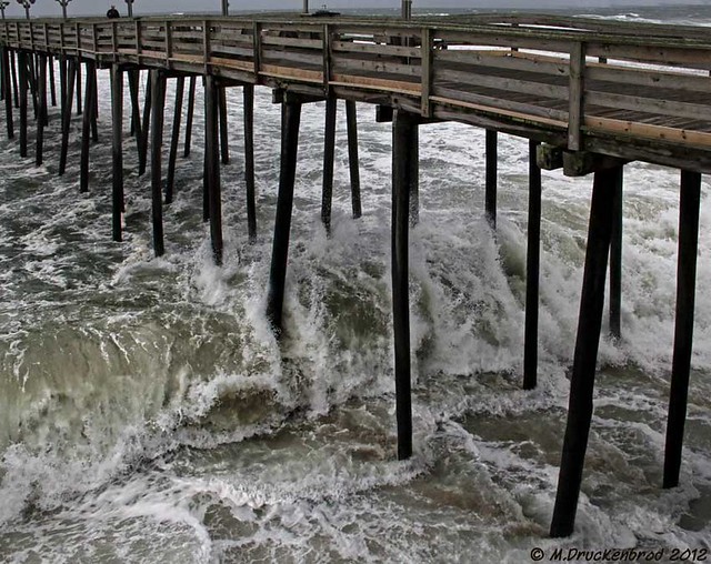
Hurricane Sandy saying hello to the Kitty Hawk Pier
Picture taken Saturday October 27 as Hurricane Sandy approaches. This
is the Kitty Hawk Pier that is currently on the storm news from The
Weather Channel.
Unfortunately my Outer Banks photo shoot had to end a couple days early as we decided to "Get out of Dodge"
Unfortunately my Outer Banks photo shoot had to end a couple days early as we decided to "Get out of Dodge"
A Hurricane Sandy rain band over the town of Kitty Hawk NC
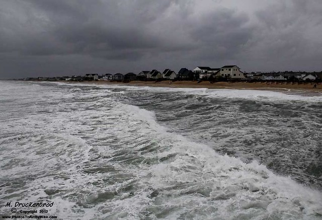
Looking south from the Kitty Hawk Pier. This was shot near mid-day, Saturday October 27, 2012.By Hazboy Ricky
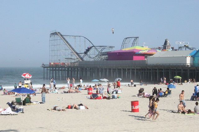
A picture of the Seaside (NJ) amusement pier before Hurricane Sandy (part 1 of 2)
I took this picture when Tricia visited me last year from Colorado. I
had not been to Seaside in a few years and coming back here with her
brought back a lot of great memories. I spent a lot of time here as a
kid, and in my teens and twenties. Besides the rides, there is a long
boardwalk with the arcade games, the ice creams and custards and the
seaside bars if you want to have a beer while enjoying a beautiful
summer day or night.
This pier is now gone. It went into the ocean overnight. Look at the white building on the right side.....now look at the next picture.
This pier is now gone. It went into the ocean overnight. Look at the white building on the right side.....now look at the next picture.
I took this picture from the boardwalk which overlooks the beach. You
will see in the next photo what part of the boardwalk now looks like
after Sandy pushed through
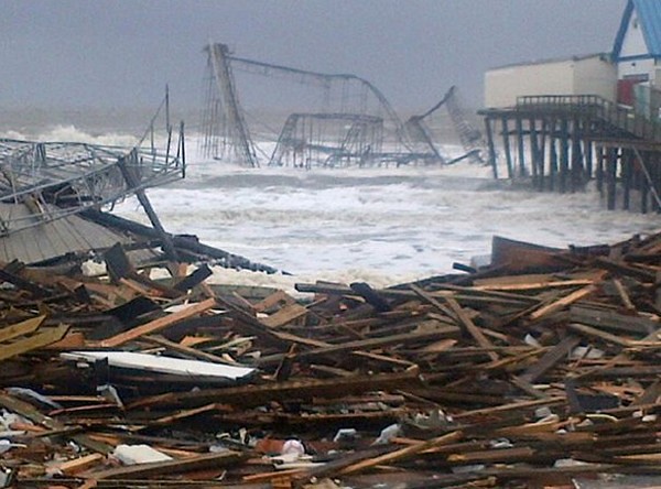
A picture of the Seaside (NJ) amusement pier after Hurricane Sandy (part 2 of 2)
There is nothing more to say. I got choked up just comparing my
previous picture of what it looked like just yesterday and for years
before.
Now that pier (and much of the Seaside Boardwalk) is damaged or
completely gone.
By Lou Prosperi 3rd.
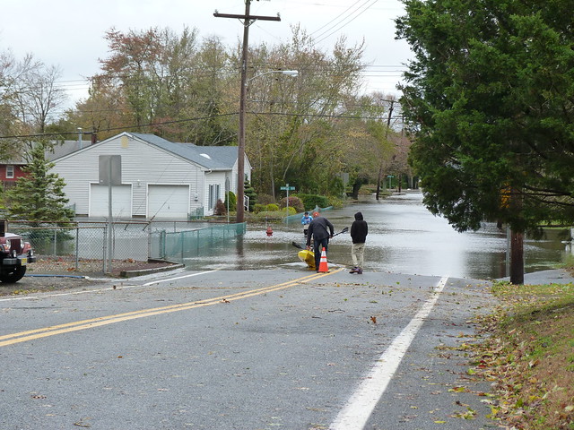
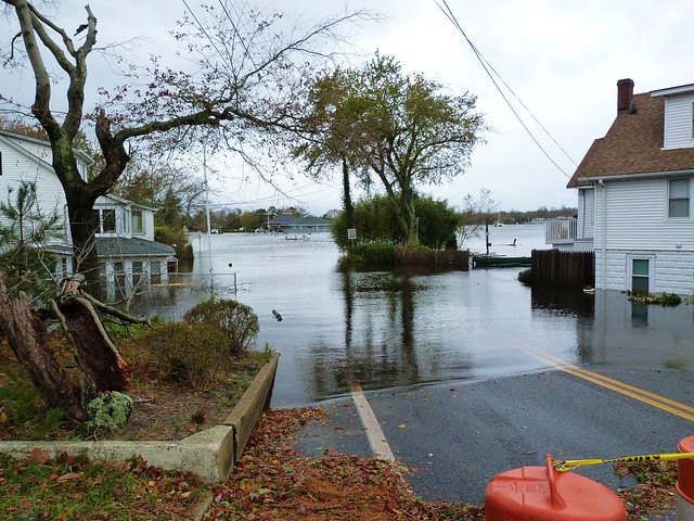
The rise of the Toms River after Hurricane Sandy
Amazing shots of the Toms River water rise after Hurricane Sandy about
a 1/2 mile down the road from our house. It is very scary to see these
images on television over the years, and then have it happen in your
own town!


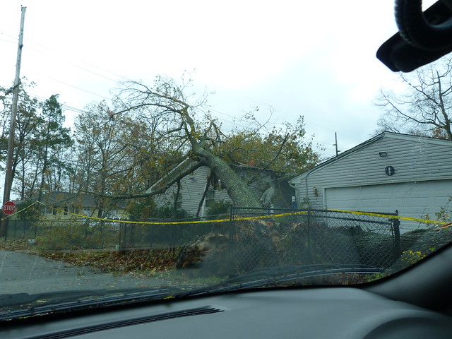
Hurricane Sandy damage around our community in Beachwood
Pictures of storm damage from around our small community here in
Beachwood, New Jersey. These are only a few of the many trees into
houses etc.. it was not really safe to ride around at this point too
many wires down and other obstacles!
By NYC Streamline
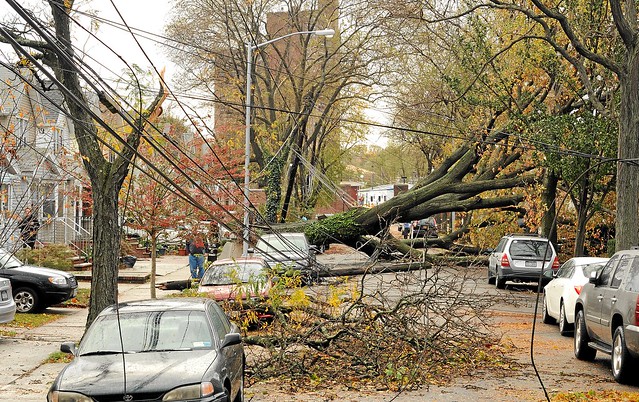
A State Of Emergency Exists In New York City.
Pictured here are downed trees and power lines presenting a serious danger to residents in Forest Hills, Queens, New York City, in the aftermath of Hurricane Sandy.Many neighborhoods are still without power, and the death toll is rising as people are found drowned in their own homes - especially in communities located close to beaches and bays which went underwater during the storm's surge.
Subways, buses, bridges, tunnels, schools, businesses, etc. are still closed.
The World's largest Financial District remains shut as portions of Lower Manhattan are still under water.
Seeping gas and exposed electrical wiring has touched off fires in water in neighborhoods throughout the Boroughs.
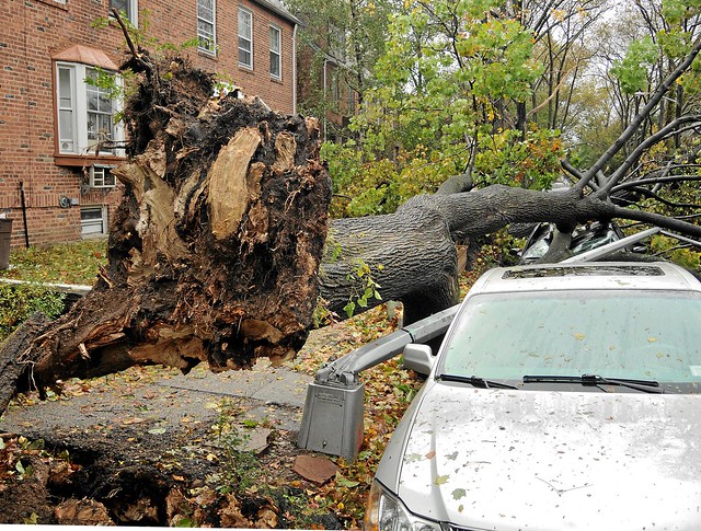
The power of Hurricane Sandy took down this tree, which in turn took
down a street light and destroyed several parked cars in Sunnyside,
Queens, New York.
The City is still reeling from the effects of this "Superstorm."
The City is still reeling from the effects of this "Superstorm."
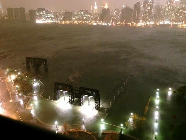
Gantry Plaza State Park, along the Queens side of the East River, in
Long Island City, Queens, New York.
For images of this beautiful park prior to sustaining damage from Hurricane Sandy, check Wikipedia: "Gantry Plaza State Park."
This photo was taken before Manhattan lost power below 34th Street.
From Brian's Lens
For images of this beautiful park prior to sustaining damage from Hurricane Sandy, check Wikipedia: "Gantry Plaza State Park."
This photo was taken before Manhattan lost power below 34th Street.
From Brian's Lens
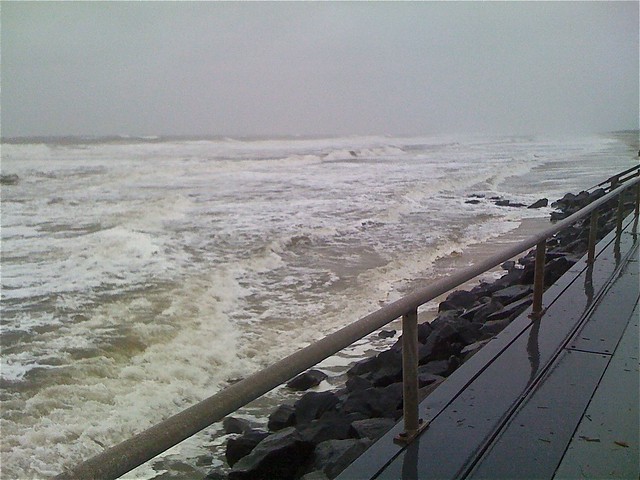
Picture taken from the boardwalk on top of the seawall at the north
end of the island at low tide on Sunday afternoon, 36 hours befor
Hurricane Sandy is expected to cross over. I expcet now at the time I
am posting this that the water is topping the seawall.

True to my prediction on my picture from the seawall yesterday, the
waves are topping the seawall. This picture was tweeted at 2 pm
Monday. But the good news is that there is not much water in the
street (yet) despite the picture allegedly showing the water coming
around behind the seawall at the end of the street (probably ablut a
blick to the left off the frame of this picture.
 Hurricane Sandy 07 - Brigantine - Liighthouse Circle
 Hurricane Sandy 02a- Aatlantic City & Brigantine - The Calm Before the Storm
 Hurricane Sandy 01c - Brigantine - Absecon Inlet
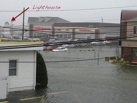
Wicked Awsome picture of what is currently happening in Brigantine.
This picture was tweeted at 2 pm on Monday. It is a picture of the
new CVS at the Lighthouse Circle in the center of town (the Lighthouse
is in the upper left edge of the picture). I suspect that this water
is all flooding from the bay which is pretty close to the Lighthouse
at this point. Yoiu are looking towards the bay, which is about a
block behind the lightouse
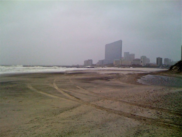
Hurricane Sandy 02a- Aatlantic City & Brigantine - The Calm Before the Storm
View from South end of Brigantine Island towards Atlantic City on
Sunday afternoon. The new $2.5 billion Revel casino towers above the
northern end of the Boardwalk. This portion of Atlantic City is
experiencing major flooding, and parts of the Boardwalk have been
sighted floating down Atlantic Avenue
View over the decks of the two very large houses on Sunset Circle
looking out over Absecon Inlet towards Atlantic City during Hurricane
Sandy. Their two decks meet in a point at the corner 25 feet from the
jetty (breakwater). The white deck (left) is parallel to the ocean,
the pink deck (right) is parallel to the inlet. Look at the map to
get a sense of how exposed this area is. The wind and waves are
usually coming towards the photographer (from that point in Atlantic
City, across the inlet, to Brigantine) and that is what you are seeing
here.
No comments:
Post a Comment