Massive Cyclone Blows Over Central Arctic Ocean
CBC | Posted: 08/12/2012 12:37 pm Updated: 08/12/2012 3:00 pm

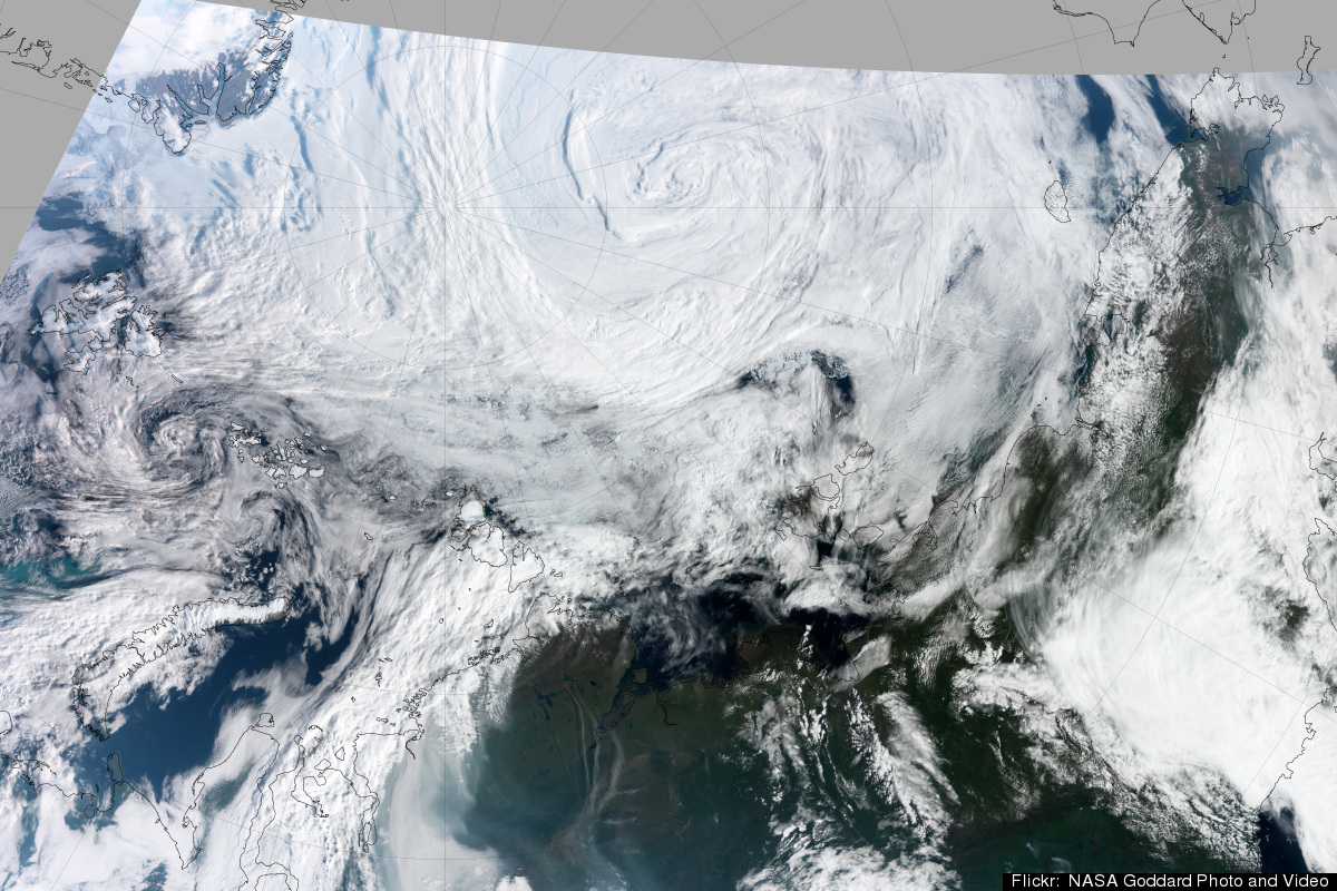
acquired August 7, 2012
A massive cyclone blew over the central Arctic Ocean this past week, north of the Beaufort Sea, and some Arctic researchers said they have never seen anything like it.
Mark Serreze, a senior research scientist from the U.S. National Snow and Ice Data Center, said cyclones are common at this time of year, but he said this week's storm was stronger than any he's seen.
Serreze said he believes the cyclone is causing Arctic sea ice to melt faster this year.
"It causes a lot of break-up of the ice floes. These can drift into warmer waters where the ice can then melt very quickly, and it looks like we're seeing some of that now, or we have, over the past week with the storm. So the point is, in terms of the sea-ice cover, it does have a big effect because with the strong winds and a big storm like that, it really chews things up," said Serreze.
He said it’s likely the Arctic sea ice cover will hit a new record low this year, thanks in part to the cyclone. Serreze added that about 600,000 square kilometres of sea ice was lost in the central Arctic in the last week.
Serreze said the Northwest Passage had been clear of ice, but now pieces have blown in to block the western entrance.
Suomi NPP View of Summer Arctic Storm

Suomi NPP View of Summer Arctic Storm [annotated]
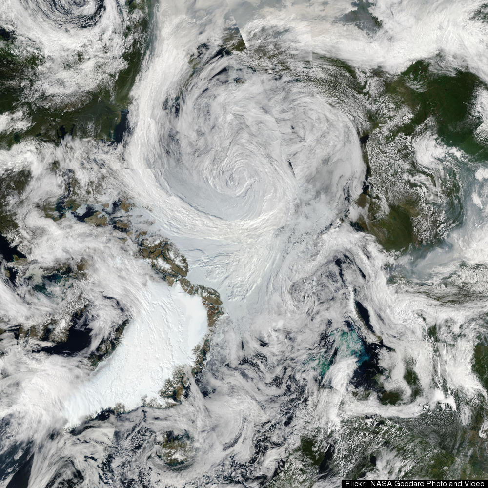
Summer Storm Spins Over Arctic
Strong Summer Cyclone Churns Over the Arctic
An unusually large, long-lasting, and powerful cyclone was churning over the Arctic in early August 2012. Two smaller systems merged on August 5 to form the storm, which at the time occupied much of the Beaufort-Chukchi Sea and Canadian Basin. On average, Arctic cyclones last about 40 hours; as of August 9, 2012, this storm had lasted more than five days.
The Visible Infrared Imaging Radiometer Suite (VIIRS) on Suomi NPP captured this view of the storm on August 7, 2012. The Moderate Resolution Imaging Spectroradiometer (MODIS) aboard Aqua captured a natural-color image of the storm as well.
Arctic cyclones are more common during the summer than winter; however, summer cyclones tend to be weaker than the storms that batter the region during the winter. This cyclone’s central sea level pressure reached about 964 millibars on August 6, 2012—a number more typical of a winter cyclone. That pressure puts it within the lowest 3 percent of all minimum daily sea level pressures recorded north of 70 degrees latitude, noted Stephen Vavrus, an atmospheric scientist based at the University of Wisconsin.
The number of cyclones affecting the Arctic appears to be increasing. According to a study of long-term Arctic cyclone trends authored by a team led by John Walsh and Xiangdong Zhang of the University of Alaska Fairbanks, the number and intensity of Arctic cyclones has increased during the second half of the twentieth century, particularly during the summer.
The cause of the increase is an open question, but climate change may be affecting Arctic cyclones. One studypublished in Atmospheric and Oceanic Science Letters, concluded that the total number of exratropical cyclones in the Northern Hemisphere would decline as the climate changed, but that the Arctic Ocean and adjacent areas would see slightly more and stronger summer storms.
One way climate change may affect Arctic cyclones is by changing the sea ice and ocean temperature. Climate change has caused sea ice to retreat markedly in recent decades and has also warmed Arctic Ocean temperatures. Such changes may be providing more energy and moisture to support cyclone development and persistence, Zhang explained.
However, scientists who study extratropical storms emphasize that pinning down how exactly climate change is affecting the size, frequency, or tracks of Arctic storms remains an important but unresolved question. “This past week’s storm was exceptional, and the occurrence of Arctic storms of extreme intensity is a topic deserving closer investigation,” noted Walsh. “With reduced ice cover and warmer sea surfaces, the occurrence of more intense storms is certainly a plausible scenario. The limitation at present is the small sample size of exceptional events, but that may change in the future.”
References
- Orsolini, Yvan. (2008, January 16). Projected Changes in Eurasian and Arctic Cyclones Under Global Warming in the Bergen Climate Model. Atmospheric and Oceanic Science Letters.
- Zhang, X. (2004, January 2004). Climatology and Interannual Variability of Arctic Cyclone Activity: 1948-2002.Journal of Climate.
Further Reading
- NASA. (2008, October 6). NASA Study Finds Rising Arctic Storm Activity Sways Sea Ice, Climate. Accessed August 9, 2012.
- NSDIC. (n.d.) Cyclones in the Arctic. Accessed August 9, 2012.
- New York Times. (2012, August 8). A Closer Look at Ice Impacts of a Rare Arctic Summer Storm. Accessed August 9, 2012.
- Tanaka, H.L. (2012, March, 2). The Structure and Behavior of the Arctic Cyclone in Summer Analyzed by the JRA-25/JCDAS Data. Polar Science.
- XWeather.org (n.d.). Arctic Cyclones. Accessed Aug 9, 2012.
NASA Earth Observatory image by Jesse Allen and Robert Simmon, using VIIRS data. Caption by Adam Voiland with information from Robert Walsh, Xiangdong Zhang, and Stephen Vavrus.
William Chapman, the University of Illinois, Urbana-Champaign, researcher who maintains the Cryosphere Today Web site, which was a source for some of the content on the Arctic Sea Ice blog. Below you can read his “Your Dot” description of the storm and analysis of its possible repercussions.
But before you read on, have a quick look at this short time-lapse video of sea ice and weather conditions in the central Arctic Ocean from early July through August 8, recorded by one of the two autonomous cameras set on the sea ice near the North Pole each spring by a research team from the University of Washington (the same folks I accompanied in 2003). [8:46 p.m. | Updated | Note: The center of the storm is hundreds of miles away from the drifting sea ice cameras.]
Here’s Chapman’s look at this summer’s powerful Arctic storm and its impact on sea ice:
I’ve been keeping an eye on this storm for a variety of reasons. First, it’s a rare event. This storm is intense for any time of year, but especially for summer, when the weather is normally fairly benign in the Arctic. This storm formed and intensified near the Beaufort Sea and moved to the central Arctic Ocean where it will slowly lose its intensity over the next several days. Ordinarily, the Beaufort Sea and the Arctic Ocean are dominated by high pressure, so having a low pressure system form and intensify here is quite uncommon. Although, it has been happening with more frequency over the past few decades as pressures have dropped significantly in the Arctic during this time and are projected to drop even more during the next century by the global climate models.Second, we’re interested in the effects of the storm on the Arctic sea ice cover. Impacts on sea ice from storms like this are typically due to strong surface winds. Surface winds can impact the sea ice both through accelerated freezing or melting (via heat transfer from the atmosphere to and from the surface) and by blowing the ice from one place to another. This storm is intense and it covers a large area so the region of the Arctic that will be impacted by strong winds is quite large.Strong winds are much more effective at transferring heat and moisture between the atmosphere and the ice/ocean surface. It’s why we blow on our tea to cool it off. The effectiveness of the heat transfer increases dramatically with increasing wind. It is a non-linear effect. However, the heat and moisture transfer is also dependent on the difference between the temperatures and moisture content between the air and the surface. In this particular case, since we are in the melt season, both the air and the ice surface are near the melting/freezing point of water and the air is near saturation, so while the winds are strong, the effects of the storm on transferring heat and moisture and therefore causing any freezing or melting will probably be limited.The effects of this storm on the ice cover therefore will be limited to redistributing the sea ice by blowing it around. The effects may be more impressive than if it occurred during other parts of the year as we are only few weeks away from the annual summer minimum in sea ice area. The ice is at its thinnest, weakest and least compacted now so it’s more free to be blown about by the winds.Low pressure systems tend to cause a divergence or spreading out of the ice pack (high pressure systems in contrast, cause convergence and compaction). The sea ice cover this summer was already very spread out. Much more of the Arctic ocean was comprised of individual broken ice floes and the pack ice had holes in it exposing ocean in many places. This storm should cause even more of that, especially in the far north where that storm will sit for a few days. To stay with the tea analogy, instead of a cup of iced tea with solid cubes floating on the surface, the storm will churn the tea into a more slushy consistency. The exposed open water caused by the wind divergence may absorb some additional sunlight and melt more ice than usual over the next few weeks (temperature-albedo feedback) [related NASA animation], but given that the sun is well on its way to setting for the winter, I think this effect will be fairly minimal.
Massive cyclone blows over central Arctic ocean
Scientist says cyclone is causing sea ice to melt faster this year
CBC News
Posted: Aug 12, 2012 10:39 AM CT
Last Updated: Aug 12, 2012 11:58 AM CT

A massive cyclone blew over the central Arctic Ocean this past week, north of the Beaufort Sea, and some Arctic researchers said they have never seen anything like it.
Mark Serreze, a senior research scientist from the U.S. National Snow and Ice Data Center, said cyclones are common at this time of year, but he said this week's storm was stronger than any he's seen.
Serreze said he believes the cyclone is causing Arctic sea ice to melt faster this year.
"It causes a lot of break-up of the ice floes. These can drift into warmer waters where the ice can then melt very quickly, and it looks like we're seeing some of that now, or we have, over the past week with the storm. So the point is, in terms of the sea-ice cover, it does have a big effect because with the strong winds and a big storm like that, it really chews things up," said Serreze.
He said it’s likely the Arctic sea ice cover will hit a new record low this year, thanks in part to the cyclone. Serreze added that about 600,000 square kilometres of sea ice was lost in the central Arctic in the last week.
Serreze said the Northwest Passage had been clear of ice, but now pieces have blown in to block the western entrance.
ARCTIC CYCLONES
Rationale behind the "Arctic cyclones" work package